 "QUANTUM SHOT" #615 "QUANTUM SHOT" #615LINK - article by Simon Rose and Avi Abrams Earth's crust: moving around at a snail’s pace - or one monster earthquake at a time Recent earthquakes have made general public aware of the Earth's crust movements as never before - not only as glacial slide over millions of years, but also as something relevant to our lifetime. Of course we are hoping that these movements will be confined to uninhabited wilderness, or at least will not occur while we are fast asleep (or maybe we'll get plenty of warning from a diligent dog, or a cat)... Most of the time, though, we just ignore all that stuff and get on with our lives. Yet here is a visual evidence that the Earth has undergone some pretty serious changes in the past and will undoubtedly experience more in the future.   (tectonic plates boundaries - see a detailed view here)  (images via 1, 2) Here are some examples of how the globe looked throughout different periods in the earth’s history. At the time of the dinosaurs, for example, the world map looked very different to the way it does today and would have been almost unrecognizable at other period’s in the planet’s geological history as well. Many are familiar with the theory of plate tectonics, which emerged in the 1960’s, and how the earth’s landmasses are moving around at a snail’s pace on its crust. It had been noticed for some time that the shapes of continents, particularly Africa and South America, resembled separated pieces of a jigsaw puzzle. Comparisons of fossils found along the edges of continents that look like they fit together, convinced scientists that the two landmasses must have once have been joined. Middle Triassic map of Pangaea (below left). Note the superimposed outlines of modern North America:  (images via 1, 2) The Himalayas were formed when India collided with Asia, while the mid Atlantic ridge plus most of the earth’s hot spots and earthquake zones are located on the boundaries of plates, such as in the Ring of Fire in the Pacific, the western coast of North and South America, the Mediterranean and so on. A number of supercontinents are thought to have existed in the distant past, which formed and broke up over the course of millions of years. The last one known as Pangaea, was formed around 300 million years ago, but it was preceded by at least six others, according to current scientific theory.  (image via) Pangaea began to break up about 200 million years ago: 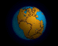 Gondwana continues to split, even today It initially split into two pieces, roughly around the same size. Laurasia included most of the landmasses that are today in the northern hemisphere while Gondwana comprised much of the land now in the southern hemisphere. Laurasia gradually moved further north, while Gondwana moved south. Gondwana comprised Africa, Madagascar, South America, Australia, New Guinea, New Zealand and Antarctica. It also included India and Arabia, which later separated and moved north. Today, the East African Rift and the Red Sea are considered to be modern examples of the continuing split of Gondwana.  (image via) During the time of the dinosaurs, the earth looked like this in the late Jurassic era, about 150 million years ago:  (image via) It had altered again by around 94 million years ago, during the late Cretaceous:  (image via) The future movements of the continents So the earth’s surface has changed dramatically over the course of millions of years and it is believed this process will continue in the millennia to come. Based on what has happened in the past, it is possible to envisage the future movements of the continents (even some online courses, namely Earth & Planetary Science MIT courses, include these models). This is the way the world may appear fifty million years from now. The Atlantic Ocean will get wider, but the Mediterranean Sea will disappear, as Africa collides with Europe. Australia and Southeast Asia will join together, and California will move in the direction of Alaska:  (map by C. R. Scotese, PALEOMAP Project) In 150 million years, further changes will have taken place:  (map by C. R. Scotese, PALEOMAP Project) Then 250 million years from now, another supercontinent, Pangea Ultima, will appear:  (maps by C. R. Scotese, PALEOMAP Project) Watch animated plates in Dance of the Continents presentation, or even move the slider "through the ages" yourself here. A look at the Earth's far future (seven billion years... and beyond) is provided in this slide show. Worlds Collide! 2012 is coming (at least to the DVD stores near you). The end of the world, according to some, will occur at the conclusion of the 5,125 year long Mayan Long Count Calendar, around the time of the winter solstice in December 2012. Haven’t we heard all this before, however, or at least something very similar? Remember Y2K? Or imagine how some people must have felt in the year 1666 or in the year 999? Perhaps you recall some of the more outlandish theories in circulation when Halley’s Comet returned in 1986? And what about those movies in the nineties about asteroid impacts, not to mention the writings of Nostradamus? Well, despite dire warnings in the past, the Earth is obviously still here and may very well be after the events that are supposedly destined to take place in late 2012. One theory regarding the movement of the earth’s landmasses, and which features in the 2012 movie, is the theory of earth crust displacement, first put forward by Charles Hapgood in his books, The Earth's Shifting Crust in 1958 and Path of the Pole in 1970. The hypothesis states that the physical north and south poles suddenly shifted, creating massive tectonic upheavals and enormous floods. According to Hapgood, at the end of the last ice age, the build up of ice in the northern part of the globe caused the crust to slip over the earth’s upper mantle. One description imagines the loose skin of an orange shifting over the inner part of the fruit, all in one piece. Hapgood’s examples of former locations for the North Pole include the northern Atlantic between Scandinavia and Iceland, Hudson Bay and Yukon:  (images via) Hapgood’s first book was published before the theory of plate tectonics appeared and earth’s crust displacement has few advocates within the geological and scientific community. The phenomenon of true polar wander is accepted, but this would move the poles one degree at the most every million years and it is believed there have been no sudden movements of the poles in the last 200 million years. Canadian writer Rand Felm-Ath corresponded with Hapgood and the theory of earth crust displacement features in his book, When the Sky Fell, which advanced the theory that the lost city of Atlantis is located in Antarctica. These speculative maps of the earth 11,600 years ago show the North Pole as being in Hudson Bay, which would of course also affect the location of the South Pole. According to this theory, crustal displacement would cause undersea earthquakes, which would in turn create massive worldwide tsunamis. The ice caps would melt and raise sea levels. Some land would be moved into warmer parts of the globe, while others would move into colder ones. If part of Antarctica once enjoyed a temperate climate before it was shifted further south, Flem-Ath’s book argues that it could indeed have been the site of Atlantis.  (original unknown) Roland Emmerich, director of the 2012 movie, claimed in an interview to have first read about the theory of crust displacement in another book influenced by Hapgood, Graham Hancock’s Fingerprints of the Gods. Hancock claims that a mysterious civilization was wiped out by a catastrophe brought on by a disruption to the earth’s crust and a polar shift. This civilization was in Antarctica, which was located in warmer latitudes before the disaster shifted it into the polar region. The civilizations’ survivors passed on their advanced knowledge to the peoples of the Americas, the Egyptians and others, thus becoming the ancestor of all of the earth’s ancient cultures. The learned community generally dismisses Hancock’s claims as pseudoscience and pseudoarchaeology, but it truly is fascinating stuff, whether you consider it based on fact or simply wildly imaginative fiction. Despite the opinion of scientists and archaeologists, Fingerprints of the Gods has sold in excess of three million copies and been translated into many different languages. Theories about massive and destructive geological changes around 10,000 years ago often involve the disappearance of Atlantis or some other lost continent or civilization, the Pleistocene extinctions and the end of the last Ice Age. They also believe the time period corresponds with the tales of a great deluge appearing in cultures around the globe, including the biblical flood. Was earth crust displacement the culprit for this and are we once again headed for disaster in 2012? The earth certainly deems destined for major changes in its future, but over the course of millions of years, rather than overnight or in the course of weeks or months. Whether a sudden change will occur, only time will tell. Stay tuned. Not a very safe place to be, during an earthquake:  (original unknown) CONTINUE TO "ONE-IN-A-MILLION COLLISIONS"! -> Simon Rose is the author of science fiction and fantasy novels for children, including The Alchemist's Portrait, The Sorcerer's Letterbox, The Clone Conspiracy, The Emerald Curse, The Heretic's Tomb and The Doomsday Mask. Simon Rose also has the video about "The Doomsday Mask" which also mentions earth crust displacement and books concerning Atlantis.  Permanent Link... Permanent Link... ...+StumbleUpon ...+StumbleUpon  ...+Facebook ...+Facebook |
Future Plate Tectonics
Subscribe to:
Post Comments (Atom)
Check out this stream
Blog Archive
-
▼
2010
(569)
-
▼
March
(12)
- Link Latte 130
- Utterly Irresistible Robot Sculptures
- Shoe Polish, Japanese Style (A New Art Form?)
- April Spring Time Coloring Pages Collections
- Gorgeous Espresso Machines
- Retrofuture Transportation Showcase, Part 2
- Link Latte 129
- The Great Sperm Race: The Most Extreme Race on Earth
- Fantastic Voyage: Mind-boggling Medical Animation
- Plane Obsessed: More Jet Hotels and Houses
- Egg Coloring Pages Collections
- Future Plate Tectonics
-
▼
March
(12)


0 comments:
Post a Comment